The Roopkund Trek is one of the most talked-about trekking routes in Uttarakhand. It is known for high-altitude meadows, mountain views, forests, snow, and the famous Roopkund Lake.
But there is more to this trek than the lake itself. The trail passes through small villages, forests, open grasslands, steep climbs, and high mountain terrain. Every day brings a different view and a different challenge.
Before planning a Roopkund Trek, there is one important thing to know. Access to the Roopkund area has been subject to restrictions, so trekkers should check the latest local and forest department rules before making any plan.
With that in mind, here is what you can expect from the trail and the experience.
Where Does the Roopkund Trek Start?
The traditional Roopkund route starts from Lohajung in Chamoli district of Uttarakhand. Lohajung is also used as a base for several other treks in the region.
The journey to Lohajung itself is part of the experience. The road passes through mountain towns and villages, with views of the Garhwal Himalayas along the way.
Once you leave the road behind, the trek starts on foot. The route then moves through forests, villages, open meadows, and higher sections of the mountain.
Day 1: Lohajung to Didna Village
The first walking day is a good introduction to Himalayan trekking.
From Lohajung, the trail climbs towards Didna Village. The route passes through forest areas and mountain paths, with sections that can feel steep even though you are still at a lower altitude.
Didna is a traditional mountain village where trekkers can get a feel for local life. Houses, farms, narrow paths, and mountain views make the first day different from the usual city routine.
It is also a good day to understand how your body responds to walking uphill.
Day 2: Didna to Bedni Bugyal
The next section takes you towards one of the major highlights of the traditional route: Bedni Bugyal.
As you gain altitude, the forest starts to open up. The trail eventually reaches large grass-covered slopes with wide views of the surrounding mountains.
Bedni Bugyal is famous for its open landscape. Unlike a forest trail where your view is limited by trees, a high-altitude meadow gives you much more space to look around.
The weather can change quickly here. Clear skies can turn cloudy, and temperatures can fall once the sun goes down.
What Is Bedni Bugyal Like?
Bedni Bugyal is one of the most memorable parts of the traditional Roopkund route.
The meadow spreads across a high mountain slope, giving trekkers a large open area to walk through. During the warmer months, the landscape can look very different from the snow-covered views people often see in winter photographs.
You may also come across small temples and local grazing areas around the meadow.
The best part is simply the view. On a clear day, several Himalayan peaks can be seen from the higher sections of the route.
Day 3: Bedni Bugyal to Bhagwabasa
This is where the trek becomes more demanding.
The trail continues towards higher altitude, and the landscape becomes more rocky and exposed. There are fewer trees as you move higher.
Bhagwabasa is located at a much higher altitude than the earlier camps. Because of this, altitude becomes a serious factor.
You may notice that your walking speed becomes slower. That is normal. At high altitude, rushing is rarely a good idea.
The focus should be on steady walking, drinking enough water, eating properly, and giving your body time to adjust.
Day 4: The Higher Trail Towards Roopkund
The traditional route towards Roopkund becomes difficult in this section.
The trail includes steep and rocky sections, and snow or ice may be present depending on the season and conditions. The terrain is not something to treat like an ordinary mountain walk.
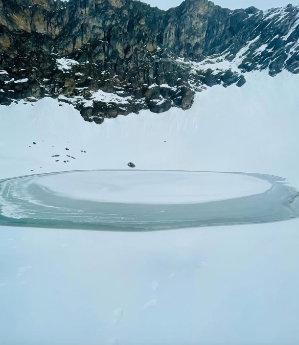
The famous Roopkund Lake is located at a high altitude of around 5,000 metres. The area is also known for human skeletal remains that were discovered around the lake, which led to the popular name "Skeleton Lake."
However, the remains are not the only reason people remember Roopkund.
The surrounding high mountain landscape is equally important. The combination of snow, rocky terrain, open slopes, and large Himalayan peaks creates a very different setting from the lower parts of the trek.
What Makes the Roopkund Trek Difficult?
Roopkund is not generally considered a beginner-level trek.
The biggest challenge is the altitude. The route climbs from a mountain village to areas close to 5,000 metres. That is a major change for the human body.
The terrain is another challenge. Long climbs, rocky sections, cold weather, and possible snow can make walking harder.
Fitness also matters. You do not need to be an athlete, but regular walking and uphill training can make a big difference.
More importantly, altitude problems should never be ignored. Headache, unusual tiredness, nausea, dizziness, or breathing problems can be warning signs. A trek leader or medical professional should be consulted when symptoms are serious or getting worse.
What Kind of Views Can You Expect?
The Roopkund route offers several types of Himalayan scenery.
Lower sections are covered by forests, while higher parts open into large meadows and rocky mountain slopes.
Bedni Bugyal is known for wide open views. Higher sections provide a more rugged landscape, with snow and mountain peaks depending on the season.
This change in scenery is one of the main reasons the traditional Roopkund route became popular among experienced trekkers.
You are not looking at the same landscape every day.
What About Snow?
Snow has always been one of the major attractions of the Roopkund region.
The amount of snow depends heavily on the season and weather conditions. Some sections can remain covered for long periods, while conditions can change quickly during the trekking season.
Snow also changes the difficulty of the trail. A route that feels manageable on dry ground can become much harder when covered with snow or ice.
That is why old trek itineraries and photographs should not be treated as a guarantee of current trail conditions.
What Should You Carry?
For a high-altitude trek, proper equipment is important.
A good pair of trekking shoes, warm layers, waterproof clothing, gloves, a cap, sunglasses, sunscreen, a water bottle, and a basic first-aid kit are useful.
You should also carry enough personal medicines and keep your backpack as light as possible.
Do not pack for every possible situation. Pack smartly and focus on things you will actually use.
Who Should Consider This Trek?
The traditional Roopkund route is better suited to trekkers who already have some experience with long Himalayan trails.
People attempting a high-altitude trek for the first time should be especially careful. Fitness alone does not remove the risks of altitude.
If you are planning a trek in the Roopkund region, check the current access rules and choose an authorised route or alternative if the Roopkund section is closed.
There are several other Himalayan treks in Uttarakhand that offer high-altitude meadows and mountain views without requiring access to Roopkund itself.
Final Thoughts
The Roopkund Trek is remembered for its changing landscape, high-altitude meadows, snow-covered terrain, and the mystery connected with its lake.
The traditional trail takes you from villages and forests to wide meadows and eventually into much higher mountain terrain. It is a demanding journey, not simply a walk to a famous lake.
At the same time, Roopkund is a route where current information matters. Access restrictions and local conditions can change, so always confirm the latest rules before travelling.
If the route is open and legally accessible, proper preparation, gradual altitude gain, suitable equipment, and respect for the mountain are essential.
And if Roopkund is not accessible, that does not mean your Himalayan trek has to stop. Uttarakhand has plenty of other trails where you can still experience forests, bugyals, snow, and big mountain views.