It takes a full day to scout a 640-acre field in central Iowa on an ATV, and you still only see the rows you drove past. The wet corner that drowned out last June, the washout along the waterway and the knoll that never holds moisture usually show up at harvest, when the yield monitor shows what you missed. Agriculture drone mapping closes that gap. A single flight gives you a measured, georeferenced picture of the whole field while there is still time in the season to act on it.
This guide covers what agriculture drone mapping produces, where it pays off, how to fly for usable data and how to choose processing software.
What Agriculture Drone Mapping Delivers
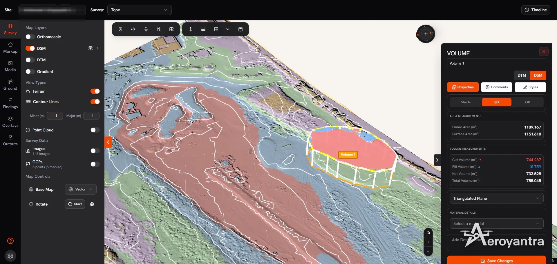
A mapping drone flies a grid and captures hundreds of overlapping, geotagged photos. Photogrammetry software rebuilds the field from them as measurable data layers. The measurements are the deliverable, not the photos.
Orthomosaics
An orthomosaic is one distortion-corrected aerial image of the entire field, scaled so you can measure distance and area directly. At common flight heights, ground resolution is often around an inch per pixel. That is sharp enough to see planter skips, wheel tracks, weed patches and storm lodging.
Elevation Models and Contours
A digital surface model (DSM) records the height of everything the camera sees, crop included. A digital terrain model (DTM) represents the bare ground underneath. Contours generated from the DTM at intervals of a few inches are the basis for drainage and land leveling decisions.
Volumes and Cross-Sections
The same elevation data measures grain piles, silage bunkers and dirt moved on a pond or terrace project in cubic yards (m³), so you no longer have to estimate them by eye.
Where Agriculture Drone Mapping Pays Off
Agriculture drone mapping earns its keep when it replaces guesswork on expensive decisions.
Drainage and Tile Planning
Standing water costs yield and delays planting. A high-resolution elevation model shows where water collects and which way it wants to run. Growers and drainage contractors use it to lay out tile lines, size outlets and plan surface ditches before a trencher enters the field.
Land Leveling and Earthwork
Cut/fill analysis compares current ground against a target surface and reports how much soil has to move, and where. On irrigated ground in California’s Central Valley or in Arkansas rice fields, that number sets the earthwork bid. Mapping the field again after the job confirms you got the grade you paid for.
Crop Scouting and Stand Assessment
With a fresh orthomosaic you can scout the whole field from the office, then walk only the spots that need attention. Emergence gaps, hail damage and insect pressure show up as patterns you would miss from the field edge.
Erosion, Conservation and Inventory
Elevation data measures how much soil gullies and failing terraces have lost, which supports conservation planning with your local USDA Natural Resources Conservation Service office. Volume measurements on grain and forage piles give you an inventory figure you can defend to lenders and buyers. Dated maps taken after a storm also document crop damage for your adjuster.
Planning a Flight That Produces Usable Data
Processing software cannot fix poor capture, so good agriculture drone mapping starts in the field.
Know the Rules First
Flights that support farm business decisions in the United States generally fall under FAA Part 107. Part 107 covers remote pilot certification, altitude limits and visual line of sight. Check the FAA’s guidance for commercial drone operators for current requirements before your first mission.
Flight Settings That Matter
Overlap: 75–80% front and 65–75% side overlap for flat cropland. Use the high end over mature corn or soybeans, because uniform canopy texture makes image matching harder.
Altitude: 200–400 feet (60–120 m) is a common range. Flying lower gives finer detail, but each flight takes longer and captures more images per acre.
Timing: Fly within a couple of hours of solar noon to keep shadows short and lighting consistent from flight to flight.
Wind: Gusts move the canopy between frames. Calm mornings produce cleaner models.
Ground Control and Accuracy
For scouting, the drone’s built-in GPS is usually enough. Drainage design, leveling and volumes depend on absolute accuracy. An RTK drone combined with a few surveyed ground control points can reach about 0.8–1.2 inches (2–3 cm) horizontal and 1.2–2 inches (3–5 cm) vertical accuracy. If a licensed surveyor (PLS) or drainage engineer will rely on the data, validate it against independent check points.
Choosing Agriculture Drone Mapping Software
The flight is the easy part. Most of the time and cost goes into turning 1,500 images into a reliable elevation model.
Factor | Desktop Processing | Cloud Processing |
Hardware | High-end GPU workstation | Any computer with a browser |
Upfront cost | Workstation plus license | Usually pay per project or subscription |
Turnaround | Limited by your machine | Runs on remote servers, often a few hours |
Sharing | Export and send files | Share results with agronomists, landlords or contractors |
Many farms, ag retailers and drone service providers who bill growers per acre fly only during short seasonal windows, so a dedicated workstation spends much of the year unused. Cloud processing removes that cost. Platforms built for agriculture drone mapping run processing in the browser. You upload images from the drone you already own and download finished deliverables, with no local hardware to buy or maintain.
Questions to Ask Any Platform
Which outputs are included: orthomosaic, DSM, DTM, contours, volumes, cut/fill?
What accuracy is achievable with RTK and ground control, and how is it validated?
Does it export to formats your GIS, farm management or drainage design tools read, such as SHP, KML, DXF or LAS/LAZ?
Is pricing per project, per acre or per seat?
Aeroyantra, for example, uses pay-per-project credits rather than per-seat licenses, which suits operations whose mapping volume swings with the season.
Building a Repeatable Mapping Program
One map shows the field on one day. A season of agriculture drone mapping lets you manage it over time. Schedule flights around decisions: pre-plant for drainage and field condition, early season for stand counts, mid-season for scouting, and post-harvest for earthwork. Keep altitude, overlap and time of day the same so maps line up.
Comparing one date against another shows whether a replant took, whether a wet spot is shrinking after tile went in, and how far a pile has drawn down since the last count. Most of the return comes from these comparisons.
Practical Next Steps
Start with one field and a problem you already know, such as a chronic wet area or a pile you want measured. Fly it, process it and check the results against what you expected. If the data changes a decision, extend the program to more acres.
Agriculture drone mapping works best as a routine part of the season, the way soil tests and yield data are. Aeroyantra offers a 14-day free trial with no credit card required, which gives you time to process a few fields and judge the output yourself.
Frequently Asked Questions
What is agriculture drone mapping?
Agriculture drone mapping means flying a drone over farmland in a grid, capturing overlapping geotagged photos and processing them into measurable maps. Typical outputs are an orthomosaic of the whole field, elevation models, contours and volume measurements. Growers, agronomists and drainage contractors use them to scout crops, plan tile drainage, level land, track erosion and measure grain or forage piles without walking every acre.
How accurate is drone mapping for farm drainage and leveling?
With an RTK drone and properly surveyed ground control points, photogrammetry can reach about 0.8–1.2 inches (2–3 cm) horizontal and 1.2–2 inches (3–5 cm) vertical accuracy. That supports drainage layout and cut/fill estimates for land leveling. Without ground control, measurements within the map stay consistent, but absolute elevations can drift. Validate against check points before design work.
Do I need an FAA certificate to map my own farm?
In most cases, yes. When a flight supports your farm business, the FAA generally treats it as a Part 107 operation. Part 107 requires a Remote Pilot Certificate and compliance with altitude, airspace and visual line-of-sight rules. Recreational rules do not cover mapping done for business decisions. Requirements change, so confirm the current rules on the FAA website before you fly.
How many acres can a drone map in one flight?
Coverage depends on the drone, battery life, altitude and overlap. A multirotor flying at 300–400 feet often covers somewhere between 50 and 150 acres per battery. Fixed-wing drones can cover several hundred acres in a single flight. Flying higher increases coverage but reduces ground detail, so plan battery swaps and landing spots before mapping large fields.
What drone do I need for agriculture drone mapping?
Any drone that flies automated grid missions and captures geotagged still images can handle basic mapping. Common choices include the DJI Mavic 3 Enterprise, Phantom 4 RTK and Matrice 350 RTK, plus fixed-wing models for large acreage. For survey-grade elevation data for drainage or leveling, choose an RTK-capable model and pair it with ground control points.